

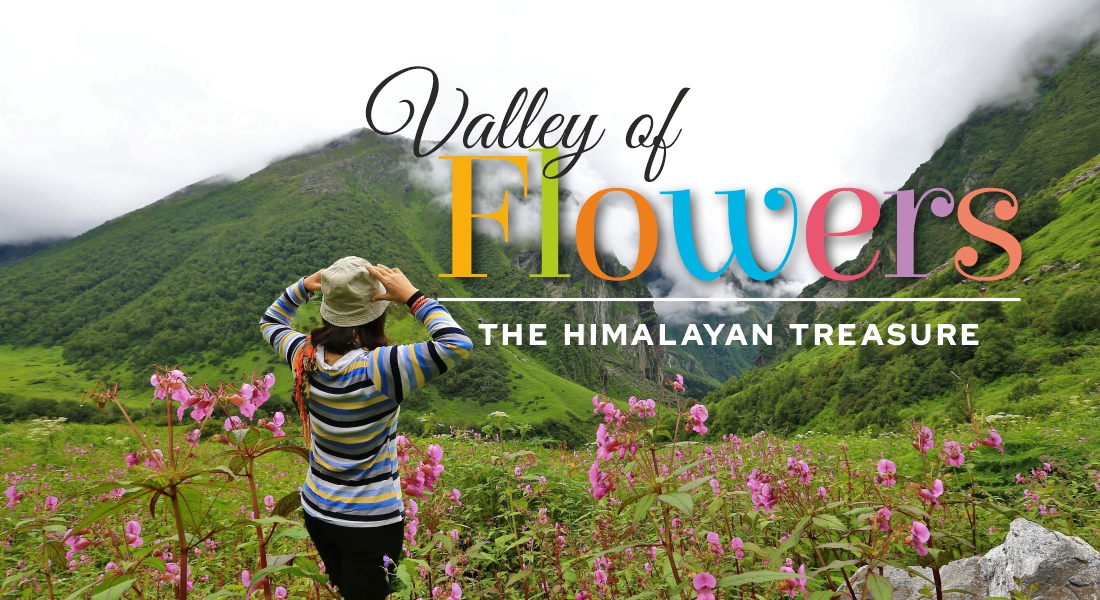
Valley of Flowers – The Himalayan Treasure
Nestled in the beautiful Himalayas is a beautiful valley called the Valley of Flowers.
Once hidden from the outside world, the valley was believed to be a playground of the gods and fairies. Frank Smith, a mountaineer and botanist, accidentally discovered the valley. He was so mesmerised by the beauty of the valley that he went on to write a book about it! The valley indeed looks beautiful, with over 300 different varieties of flowers spread over miles in the valley. I had the pleasure of visiting this valley in August of 2017.
Let me take you on this memorable journey and give you a glimpse of the valley through my eyes.
We were a group of 16 ladies from different parts of India who met at Dehradun Airport for this trek. In fact, a tour package covered Haridwar, Rudraprayag, Govindghat, Ghangaria (our base camp, and we go to the Valley of Flowers and Hemkund Sahib from here) and back to Dehradun in the same way, covering all the places in reverse order.
Day 1: Dehradun–Haridwar (53 km) Drive time: 2-3 hours
We arrived in Dehradun from our respective cities. Dehradun Airport, also known as Jolly Grant Airport, is the smallest airport I have ever seen. We began our journey towards Haridwar after having lunch at Padmini Palace. Later in the evening, around 5:45 p.m., we drove to Har ki Pauri for the famous Ganga Aarti. Aarti in Haridwar is a spectacle, with hundreds of pilgrims chanting and praying together. It was really nice to be a part of this mesmerising experience with a huge crowd offering prayers in the setting sun. Located at the point where the Ganges emerges from the Himalaya, Haridwar (also called Hardwar) is Uttarakhand’s holiest city, and pilgrims arrive here in droves to bathe in the fast-flowing Ganges.
Day 2: Haridwar–Rudraprayag (165 km) Drive time: 6-7 hours
After an early breakfast, we started our journey to Rudraprayag. Haridwar to Rudraprayag is a scenic drive along the Ganges up to Devprayag and along the Alaknanda up to Rudraprayag.
Named after Lord Shiva, Rudraprayag is one of the Panch Prayags of the Alaknanda River.
We got lucky to see all the Panch Prayag during our trip –
- Devprayag -> where river Alaknanda meets river Bhagirathi
- Rudraprayag -> where river Alaknanda meets river Mandakini
- Karnaprayag -> where river Alaknanda meets river Pinder
- Nandprayag: -> where river Alaknanda meets river Nandakini
- Vishnuprayag -> where river Alaknanda meet river Dhauli Ganga
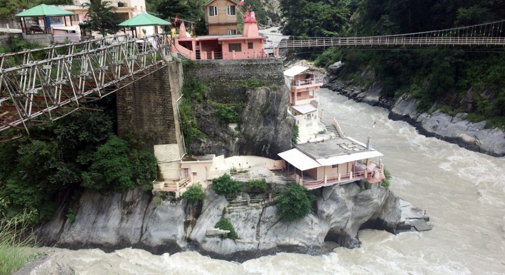
We reached Rudraprayag late in the evening. Our stay for the night was arranged at Monal Resort, which was situated in a beautiful location and offered a wonderful view of the Alaknanda River flowing ferociously at the backside. We were so excited to see the river that we directly headed towards it.
This hotel is named after the Monal Bird, which is the state bird of Uttarakhand.
Day 3: Rudraprayag–Govindghat (135 km) Drive time: 5-6 hours
We made an early start to Govindghat today from Rudraprayag.
We had a surprise element en route from our tourist guide, which was Badrinath Temple (this was not part of our package tour). The roads were blocked due to landslides until a few days before we arrived. We were lucky that these blockers were cleared, and we could visit the temple.
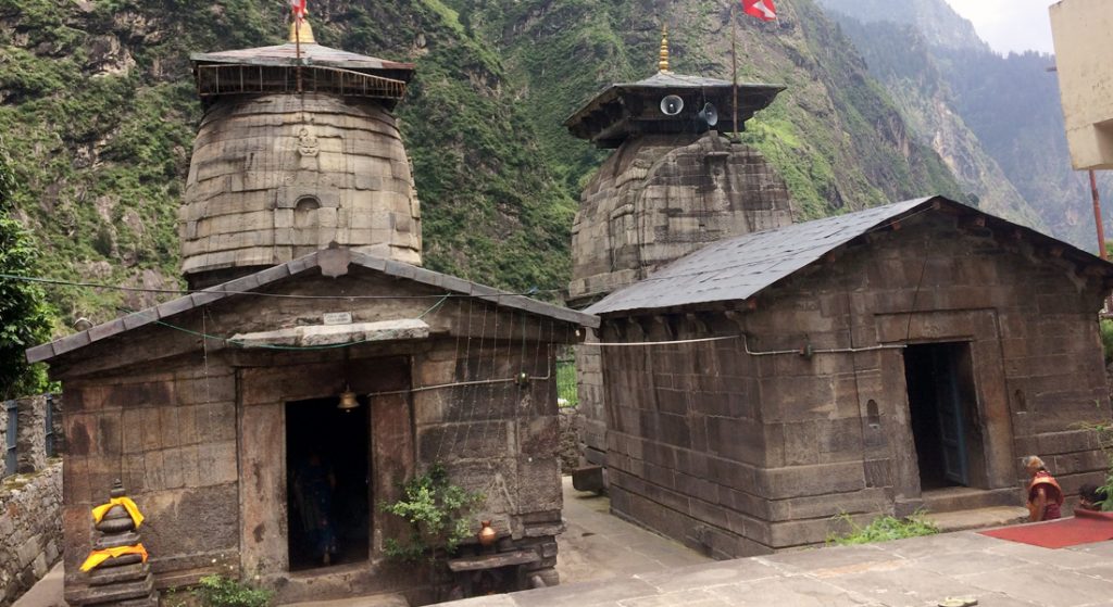
We reached Badrinath Temple by noon. This is one of the most visited pilgrimage centres in India and one of the four Char Dhams. The image of the presiding deity worshipped in the temple is a 1 m (3.3 ft) tall, black stone statue of Vishnu in the form of Badrinarayan. We got to see the Tapt Kund, which is a hot-water pond. The water in this pond is hot throughout the year, and many pilgrims consider it a requirement to bathe in the springs before visiting the temple.
After our visit to Badrinath Temple, we went to Mana Pass. Mana Pass is a mountain pass in the Himalayas on the border between India and Tibet. It appears to now be one of the highest vehicle-accessible passes in the world, containing a road constructed in the 2005–2010 period for the Indian military by the Border Roads Organisation. We started our trek to the road from Mana Village, which is the last Indian village situated at the Indo-China border. It was a steep climb uphill to reach the Indo-Tibetan road. En route to climbing this hill, we saw Vyas Gufa. Vyas Cave is an ancient cave located on the banks of the Saraswati River at Mana village in the Chamoli district of Uttarakhand. Vyas Gufa is believed to be the place where sage Vyas composed the Mahabharata epic with the help of Lord Ganesha. A distinct feature of the temple is the roof, which resembles the pages from the collection of his holy scripts.
Ganesha cave is also located in a nearby area below the Vyas cave. Bhim pul is a natural rock that rests over the river near this temple.
There is also an interesting story related to the place that explains the broken tusk of Lord Ganesh. When Vyas was composing the Mahabharata, he needed someone to take down his dictation and asked the learned Ganesha for the same. Ganesh agreed, but he had a condition: that Vyas would not stop, even for a moment, or else he would stop writing and leave. Vyas was dictating as fast as he could, and Ganesh bent down over the script pages. Finally, his reed pen broke. To that end, he broke off a part of his tusk to be used as a pen.
Finally, we made it to the top and landed right on the Indo-China road.
We started walking on the road, and at one point we noticed the Saraswati River flowing ferociously. Mana Pass is the source of the Saraswati River, the longest stem of one of the longest Ganges tributaries, the Alaknanda River. The mythical Saraswati River flows into the big orifice in the ground before it disappears. En route, we crossed Joshimath, the winter home of Lord Badrinarayan, when the temple at Badrinath closes. It is considered one of the most sacred places by Hindus, who believe that Badrinath (the God Vishnu) resides here in winter.
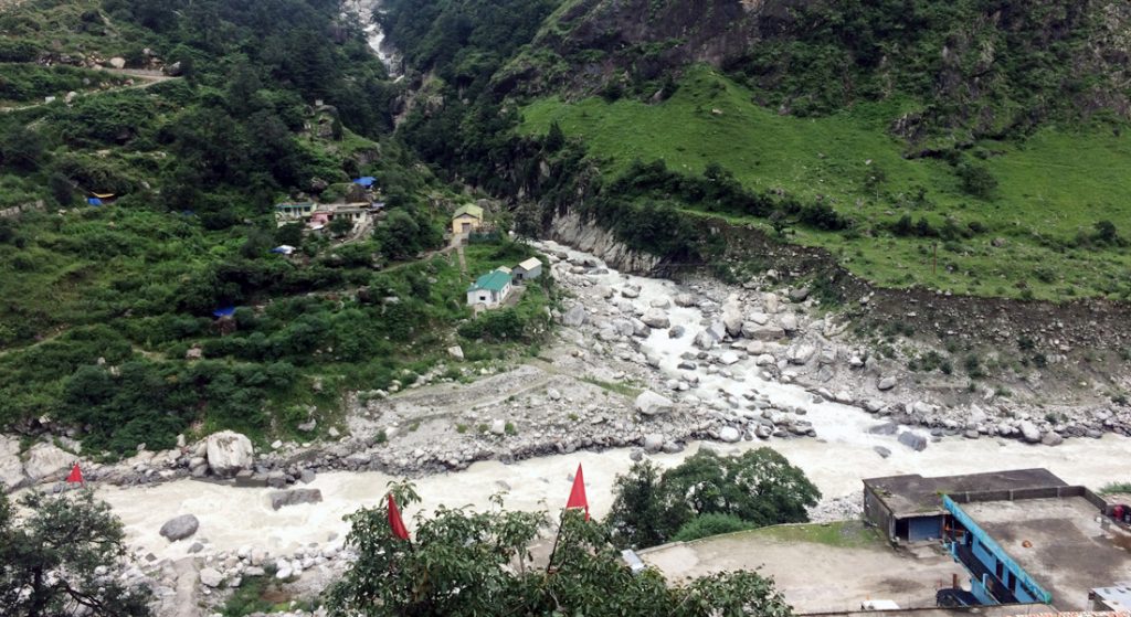
Finally, we reached Govindghat late in the evening, which is located in the Chamoli district of Uttarakhand and is beautifully situated at the convergence of the rivers Alaknanda and Lakshman Ganga. We stayed at the Bhagat Hotel for an overnight stay, and the view from the hotel was awesome.
Day 4: Govindghat—Ghangaria (Trek: 9 km/ 6 hours approx.)
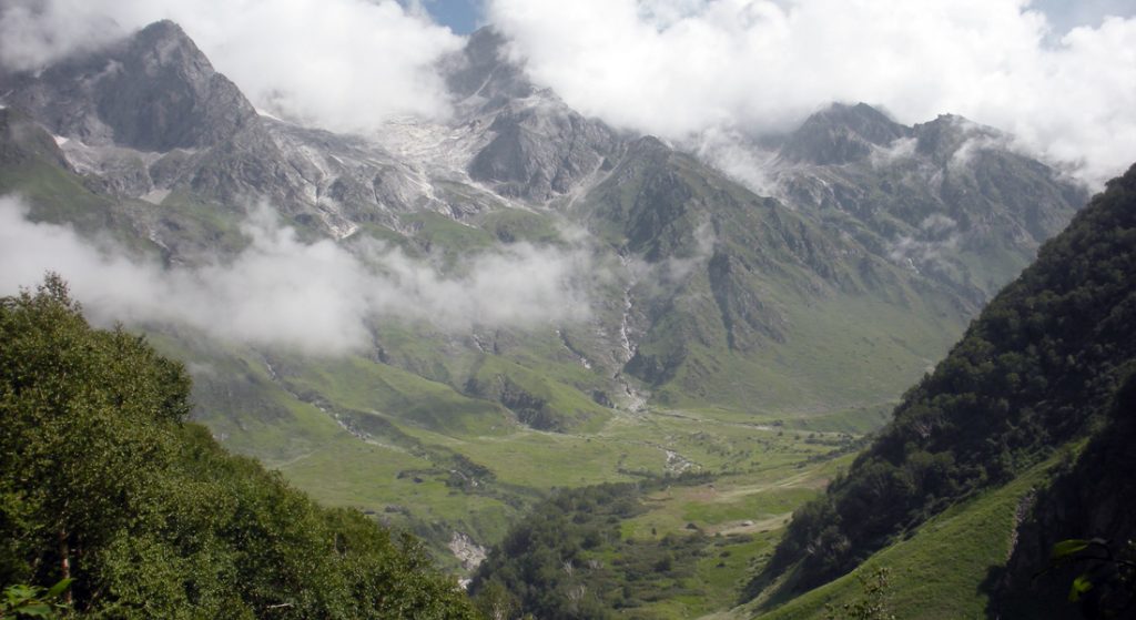
We started early in the morning on our trek to Ghangaria (9 km) from Govindghat. Ghangaria is also the base camp for the treks to the Valley of Flowers. It is situated at the confluence of the rivers Bhyundar Ganga and Pushpawati, which form the Lakshman Ganga. It is the last human habitation in the Bhyundar valley. This place is usually used by travellers as a base camp to visit Hemkund Sahib and the Valley of Flowers. It is only open from May until September. The rest of the year, the valley is covered in snow.
We started walking down from the hotel to the base point, where we could take a shared jeep and go to the starting point of the trek. En route, we took nice pictures of the surrounding valley in Govindghat.
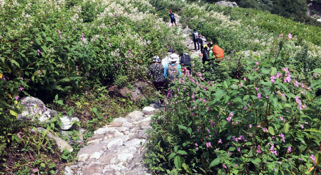
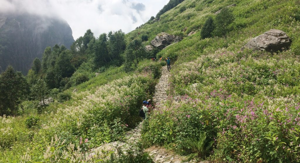
The good thing about this trek is that there are markers. That means you know you have walked 2 kilometres and you need to walk 7 more. The path winds around the River Lakshman Ganga for most of the way.
It is a good trek as it does not go uphill all the way. There are short sections that are flat, and some are even downhill. Most of the way is uphill, but gradually uphill. A lot of ponies (mules) carrying people and our baggage ply the way and act as our speed breakers. Also, there are some tea shops after some kilometres for you to take refreshments, regain energy, and start again. You get to meet a mixed crowd en route for this trek, where a lot of people are pilgrims to Hemkunt Sahib rather than trekkers, and it makes for an interesting mix. Finally, we made it to our Ghangaria tents in the evening at 5 p.m. We stayed overnight at our camps in Ghangaria village.
Day 5: Ghangaria—Valley of Flowers (Trek 3 + 3 km to the entry point)
Ghangaria to the Valley of Flowers entry point is a gradual uphill hike of 3 km and a scenic trek that greets you with a cool breeze and breathtaking views. The entry gate to the park is close to Ghangaria; however, we need to walk 3 kilometres, moderately uphill, to reach the valley. After the entry point, you are free to move around at your own pace to enjoy the scenic views of the valley.
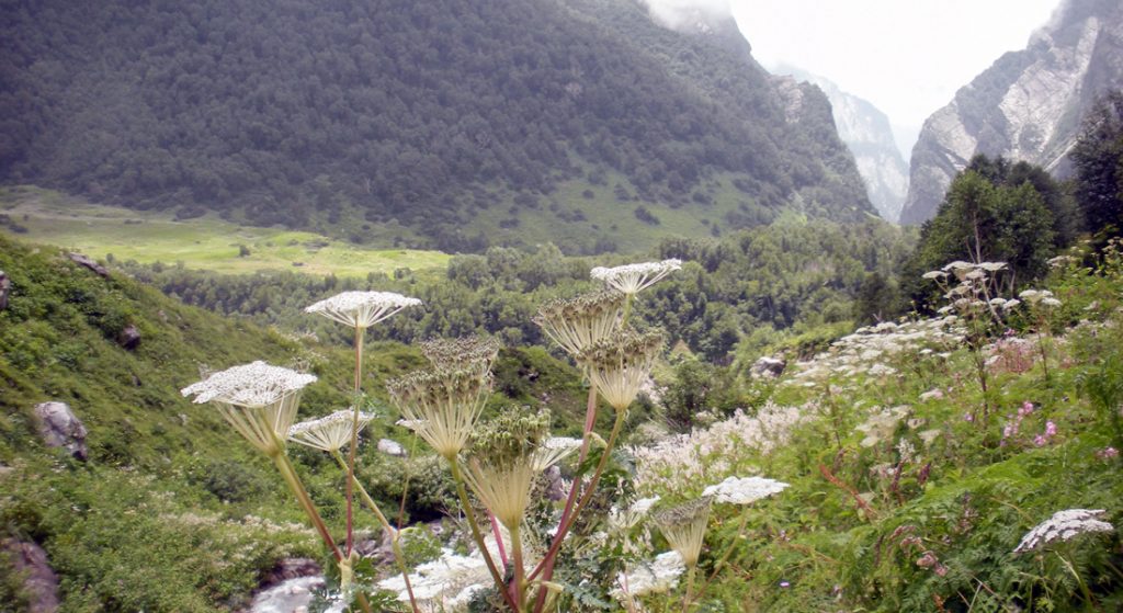
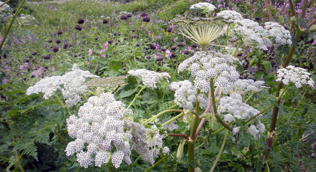
The Valley of Flowers is a UNESCO World Heritage Site. The flora includes orchids, poppies, primulas, calendulas, daisies, and anemones, as well as rare species like the Brahmakamal, the Blue Poppy, and the Cobra Lily.
We did have a botanist with us who was explaining each and every flower. But I don’t think anybody is going to remember the names. Hence, while I was in the park, I took a picture of the list of each flower in the valley.
A stone path meanders among the flowers and across streams. This stony terrain into the valley is a little tough to climb, so watch out for your feet. Thanks to our guide, we were asked to carry two trekking poles for support. The flowers are so beautiful that leaving the path is difficult. Few visitors returned after reaching the centre of the valley, but we continued beyond the first one or two kilometres inside the valley. I was quite excited to see these rare flowers and went on clicking pictures of flowers and also drinking from a mountain spring.
Day 6: Ghangaria—Hemkund Sahib (Trek: 6+6 km/ 4 hours each way approx.)
We started on our trek early in the morning to Hemkund Sahib. This is a moderate trek, 6 kilometres each way, and usually takes about 4 hours each way. The climb to Hemkund Sahib is pretty steep, as it is the world’s highest Gurudwara and is located near a beautiful glacial lake surrounded by mountains. It is a pilgrimage place for both Hindus and Sikhs. The name Hemkund Sahib denotes the presence of a tank of snow. On a clear day, one can catch a beautiful reflection of the Gurudwara in the lake.
The trail is wide and very well maintained. We saw a lot of people on this path, some known faces whom we met on VOF, and the rest were pilgrims. And of course our closest companions—Poni’s? Trekking uphill is really beautiful and scenic.
Initial early morning trekking was good, but after around 4 hours, it started taking a toll on me. I had two friends who were slow walkers like me, and we maintained the same pace on the first two days. Hence, we were walking partners. It so happened that when we stopped at 11 for tea, people from our tent who had started 2 hours later than us crossed us. So we knew we had to gear up now. Then, somewhere far from Gurudwara, we heard the bhajans, and that really motivated us to walk ahead. Finally, after 7 hours, we made it to Gurudwara. Our guide instructed us to first go near the lake, wash our legs, and photograph the Gurudwara.
The lake also has a small temple devoted to Lord Lakshman. People say this is the only Lakshman temple in India.
Whatever time I was there, the lake was surrounded by mist, and a little later it almost completely vanished from the view. We visited both the temple and the gurudwara. A little later, we ate khichdi and had tea from the langar. Then it was time to head back.
Now it was time to climb down the same distance again, but at a slower pace. We spotted the famous flower, Brahmakamal. Brahma Kamal is another exotic flower that is not found in the VOF but is en route to Hemkund Sahib. Walking down, our guide took us through a shortcut that was all steps climbing down. We took a lot of breaks climbing down since the major milestones of the trip were achieved. Finally, we reached Ghangaria village and hogged some nice Maggie and tea. Now all we were looking forward to was going back to Govindghat from Ghangaria camp the next day.
We trek back to the Ghangaria camps for the night.
Day 7: Ghangaria—Govindghat (Trek: 9 km/6 hours) —Rudraprayag (135 km) Drive time: 5-6 hours
We started our return journey today with a trek down to Govindghat early in the morning at 7, since later in the day the sun would be too strong.
While some of us decided to trek back, some decided to go on ponies, and others preferred to take a helicopter to enjoy the scenic view from above. I decided to take a pony for a change, but descending downhill on a pony was a completely different experience altogether. This time we got to enjoy the scenic view better since there was no target to be reached and we clicked some nice pictures on the way back. On arriving at Govindghat, we went to the Yogadhyan Badri Temple, which is located at Pandukeshwar near Govind Ghat. When the temple of Badrinath is closed during the winter, Yogdhyan Badri serves as the abode for the Utsav-murti, or festival-image, of Lord Badrinath. Hence, it is religiously mandated that a pilgrimage will not be complete without offering prayers at Yogadhyan Badri.
We came back to the Govindghat hotel and started our journey to Rudraprayag. We stayed overnight at the same Monal Resort.
But the best part was the evening view of the Alaknanda River, which we had seen while on our onward journey. The mist covered it completely.
Day 8: Rudraprayag—Rishikesh—Haridwar (163 km) Drive time: 5 – 6 hours
We started our journey from Rudraprayag to Rishikesh.
Rishikesh is also known as the “Gateway to the Garhwal Himalayas” and the “Yoga Capital of the World.” There are a lot of yoga centres that attract tourists.
It is also a popular spot for adventure sports. We saw a lot of signboards for bungee jumping, hiking, kayaking, mountain biking, rock climbing, rappelling, and zip lining. Rishikesh is becoming a popular spot for whitewater rafting enthusiasts, both from India and abroad, as the Ganges offers medium-to-rough rapids.
We had lunch in an Italian restaurant since we were bored eating dal, roti, and aloo gobi all the time. After lunch, we started to head towards Lakshman Jhoola. This is an iron suspension bridge across the Ganges. The bridge connects the two villages: Tapovan in Tehri Garhwal district and Jonk in Pauri Garhwal district, crossing the river from west to east.
We crossed the bridge, surrounded by animals, cars, and people, and arrived on the other side. I quickly checked out some shops but did not find anything worth taking home. We came back to our coaches and started our journey back to Haridwar.
Day 9: Haridwar—Dehradun (53 km) Drive time: 2–3 hours
On the last day of our trip, after breakfast, we headed to Dehradun airport to catch our return flights to our respective cities, carrying a baggage full of wonderful memories.
This is a guest post on the blog www.thelightbaggage.com from Smita Shanbhag, a traveller who likes exploring new places and going on adventure trips.
Article and photos by Arun Bharadwaj – https://www.thelightbaggage.com/
*The views expressed in the article are those of the writer alone. Chaloindiaworld.com does not own any responsibility in any form if there is any wrong representation of facts or places.
**The copyright of all the photos and text content of this article is owned exclusively and only by Arun Bharadwaj, the author of this article. No one else has any right to copy/publish/print/download any photo(s) or text content of this article, either in part or in full, and use them for personal, professional, or any other purpose. For any such usage, prior written consent from the author is a must.